Four weeks ago we experienced a thunderstorm in the Eldorado
area that put an exclamation point on our Monsoonal moisture season. To put it
in perspective, It’d been dry, very dry: I’d been telling folks here it was the
driest I’d seen the “greenbelts” in Eldorado during my 24-year residence here.
There was little fire danger because of a lack of one-hour fuels; grasses
hadn’t grown – just dust (and it isn’t combustible). We are used to NOT having moisture here: it is
the historic norm. I noticed that over a year ago SF County Roads replaced a
culvert-end in my neighborhood with an enlarged hole & pipe. When I pointed
out to County Roads that the other end was still buried (and had been for decades),
they came and placed a stake where they thought the end of the buried culvert
pipe should be. I guess they’re not used to dealing with water either, the
stake is still there…
The drought in the western US has been greatly noted,
chronicled & discussed:
With local commentary & history too As noted by Heller in his op-ed (linked below), there have been wetter
times locally. In fact, during the late 13th & early 14th
centuries (common era) the Galisteo Basin supported the largest pueblos and
densest populations in what is now the Southwestern U.S.A. Yep, with many
having 1,000-2,000+ rooms they were larger than Chaco or Mesa Verde. This came
about because of a wetter time period, much like recently experienced in this
vicinity. When the more normal conditions of water scarcity returned,
populations plummeted as inhabitants moved closer to water sources.
http://www.santafenewmexican.com/opinion/my_view/article_6c9a4b95-06be-5444-b05a-b5d758d2c4c9.html |
| grapes of unwrath |
The storm here 4-weeks ago was the largest-widespread
over-the-area in quite a while. As the author Michael McGarrity (lives nearby) mentioned to me: “it really
changed the landscape.” Indeed, it moved a lot of earth, sand, brush &
trees. Plus, brought out a cycle of chorus frogs. But it was nothing compared
to the WATER experienced some places http://www.youtube.com/embed/_yCnQuILmsM
- like Manitou Springs recently, or North Cascades National Park:
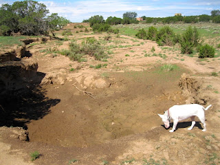
BUT, I want to share a few images of our little micro-event:
 |
| doesn't look like much, but debris atop concrete is 10' 6" above channel |
 |
| trail - used to be level |
 |
| Lucy checks arroyo erosion area - had been filled with cut cholla (once again displaying the universality of studity) |
 |
| Another trail washout |

